by Eric Hirst
With rare exceptions, everyone in Washington must have a water right to legally draw water from streams, rivers, lakes or from groundwater wells. Some farmers in Whatcom County, however, are using water without state authorization.
Informal and undocumented estimates from the Washington Department of Ecology, the Nooksack Indian Tribe and Whatcom Farm Friends state unpermitted agricultural water use includes “up to 70 percent,” “20 to 30 percent,” and “30 to 60 percent.” The degree of noncompliance with state law likely varies greatly, with some water users drawing more than their water rights allow, but some water users lack any right at all. The Bertrand Watershed Improvement District (WID) noted: “… there are conflicting records on the status of water rights within the WID. Land is irrigated under a mosaic of permits, certificates, claims and non-permitted use.” (1)
This article develops a methodology to identify the extent and locations of unpermitted water use in the Whatcom County agricultural sector; roughly quantifies permitted and unpermitted water use; and suggests policies to bring farmers into compliance with state water law.
Data on water rights and land-use patterns along with GIS (Geographical Information Systems) software was used to identify the locations and extent of lands that might be using water without the right to do so. Because of limitations and deficiencies in the various datasets, it is not possible to make definitive statements about who is and is not using water legally. Three sets of errors complicate interpretation of the results presented here:
• Errors in the data. The Ecology database contains many errors and omissions, which are difficult for a nonexpert to identify and correct. (2)
• The Western Washington University students who conducted this GIS analysis know a lot about GIS software but little about Whatcom County water issues or agriculture. They therefore lacked the ability to assess the reasonableness of their assumptions and results.
• I know something about local water issues, but nothing about GIS. I therefore lacked the ability to assess the validity of the students’ decisions.
Given these caveats, does it make sense to read the rest of this paper? I think it does because unpermitted water use is a major issue in Whatcom County, and addressing and resolving this issue is feasible. This analysis shows that more than one-third of irrigated crop acreage is using water without authorization from Ecology, accounting for more than 40 percent of the total water used for agricultural irrigation. And, as shown below, the six WIDs are ideally suited to address and resolve this issue.
Background
The issue of unpermitted water use may have no villains. Some farmers using water without authorization have been trying to get permits for 30 years. Ecology notes that water in the Nooksack River basin is over appropriated, and state law does not allow the department to issue new water rights. The state legislature has not decided the issue.
Unfortunately, the current situation, while understandable, creates serious environmental and legal problems. Summer flows in the Nooksack River and many of its tributaries are below the requirements set by Ecology: (3) “From 1986 to 2009, flows in the Nooksack River failed to meet instream flow-rule requirements 72 percent of the time during the July-September flow period,” (4,5) which limits Ecology’s ability to issue water rights.
“Most water in the Nooksack watershed is already legally spoken for,” Ecology has reported. “Increasing demands for water from ongoing population growth, diminishing surface water supplies, declining groundwater levels in some areas during peak use periods, and the impacts of climate change limit Ecology’s ability to issue new water rights in this watershed.” (6)
Due in part to these low flows, the numbers of salmon and steelhead in our waters are very low relative to historical levels, leading to their listing as threatened under the federal Endangered Species Act.
The Lummi Nation and Nooksack Indian Tribe have treaty rights dating to 1855 and perhaps to “time immemorial” that guarantee them the right to harvest salmon. These rights are meaningless unless salmon populations can support a harvestable surplus of salmon.
Agriculture accounts for 68 percent of Whatcom County summer water use (July, August and September), so bringing farmers into compliance with water law is important to help replenish salmon runs. (7) Increasing summertime instream flows in the tributaries and mainstem of the Nooksack River may require less human use of water during that period.
Data Sources
The sources used for this project include:
• Water rights from Ecology, its Geographic Water Rights Information System (GWIS). These data were used to determine the spatial distribution (locations and acreage) of water rights for agricultural irrigation in Whatcom County. (8)
• Crop distribution data for 2014 from the Washington State Dept. of Agriculture (WSDA). These data were used to determine the spatial distribution of crops and the use and types of irrigation equipment in Whatcom County. (9)
Results
Whatcom County has 49,500 acres of irrigated cropland. Of this area, as much as 18,600 acres (38 percent) might lack a water right (Table 1). Grass/hay and corn account for the most unpermitted acreage, almost two-thirds of the total.
Irrigation water use totals 68,600 acre-feet. (10) Of this amount, 44 percent is drawn without a water right. Grass/hay and raspberries dominate unpermitted water use, accounting for two-thirds of the total.
Another way to look at water use is by Watershed Improvement District (WID (Fig. 1).

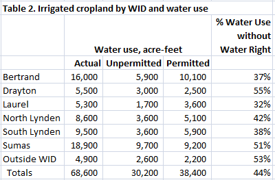
The six WIDs account for more than 90 percent of the irrigated acreage and unpermitted water use in Whatcom County (Table 2). By far, the Sumas WID has the greatest acreage irrigated without a water right (6,600 acres), and the Drayton WID has the highest percentage of land irrigated without a right (50 percent).
With respect to water use, the Sumas WID contains the largest amount of unpermitted water use, followed by Bertrand (Table 2). The Drayton and Sumas WIDs contain the highest percentages of unpermitted water use, 55 and 51 percent, respectively.
Policy Implications
Assuming these results are roughly correct, what can be done to correct the situation? Fortunately, the data suggest a solution that is — conceptually at least — straightforward. The solution is to focus on the WIDs and allow/encourage each WID to solve its water-rights problems in whatever fashion works best for that WID.
Permitting the WIDs to identify, develop, negotiate and implement solutions would require approval, and possibly financial assistance, from Ecology. Because state water law might not allow such a comprehensive approach to dealing with this problem, the state legislature might need to provide Whatcom County with a temporary (say five to 10 years) exemption from certain aspects of water law.
Each WID would follow a two-step process:
• Identify the locations and amounts of water used for irrigation, both with and without water rights;
• Establish a local water market or other mechanisms to facilitate the sale/lease or other transfers of surplus water rights to those who lack them.
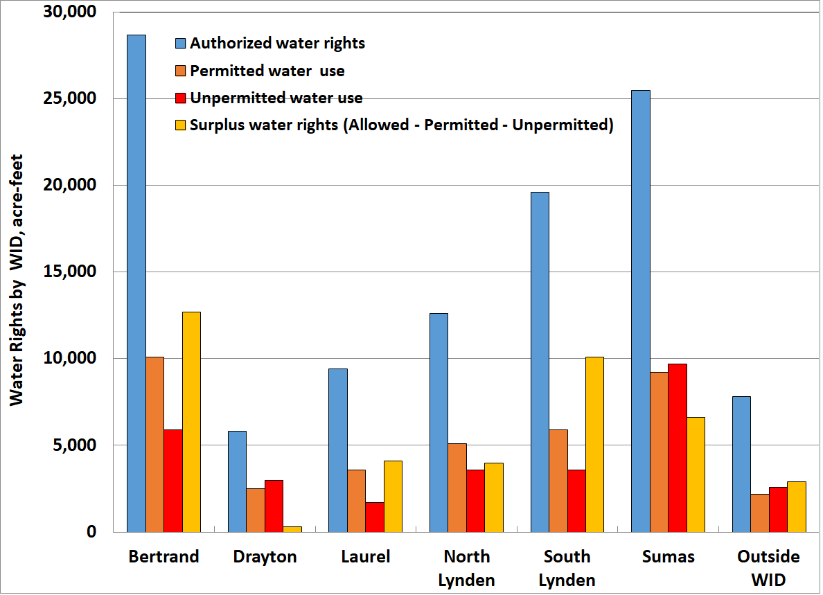
Why focus on WIDs? The six WIDs are government entities with the power to tax and, therefore, to conduct meaningful projects. Also, the magnitude of water rights in all six WIDs is more than enough to cover all the existing permitted and unpermitted irrigation water use (Fig. 2).
“Surplus” water rights are those greater than what is actually used (both permitted and unpermitted) in the particular area, e.g., WID or watershed. (11)
Perhaps most important, the WIDs were created by farmers and are run by and for farmers. Farmers are therefore likely to trust their WID and be willing to work with the WID to accurately determine where and how much water right exists and to identify irrigated acreage that lacks a water right. These WID-specific data and calculations would replace the estimates provided here and produce a more detailed and accurate picture of water use and water rights.
Consider Bertrand, the oldest WID. About 30 percent of its nearly 11,000 acres of irrigated land lacks a water right. And just over one-third of its water use lacks a water right. But Bertrand farmers, in aggregate, hold rights to almost 29,000 a.f., far more than the 16,000 a.f. actually used. Thus, farmers holding more rights than they use could sell or lease these rights to those farmers who lack sufficient or any water rights. If enough deals were made to cover all irrigation water use in this WID, the farmers would still have almost 13,000 a.f. of “extra” water rights.
If this solution is so straightforward, why hasn’t it already been implemented? The answer, I believe, is because state water law is so complicated and, in some cases, counterproductive.
For example, the use-it-or-lose-it requirement (“relinquishment”) prevents farmers from admitting they might not be using all the water to which they are entitled. (12) If a farmer with enough rights to cover his/her irrigation use improves efficiency of irrigation scheduling, is more conscientious about maintaining and repairing irrigation equipment, and/or installs more efficient equipment, then water use will drop. Under current state law, Ecology is obligated to take away that unused water right, a serious obstacle to both efficiency improvements and water markets.
Each water right is specific about the point of diversion/withdrawal, point of use and purpose (e.g., domestic, industrial or irrigation). A farmer wanting to “spread” an existing water right over more acreage (e.g., made possible by the kinds of efficiency improvements noted above) is required to file a change application with Ecology, which could be lengthy, complicated, uncertain and expensive.
In addition to the complications and obstacles associated with state law, resolving this issue of unpermitted water use would require negotiations with other interests, especially the Lummi Nation and Nooksack Indian Tribe. While I can’t speak for either tribe, my guess is that they would accept the kind of solution proposed here only if the result included more water left in the tributaries and mainstem Nooksack River. A final deal might, as an example, require that a certain percentage (10 percent? 25 percent?) of the water rights transferred to farmers who now lack these rights be used to increase instream flows. (13)
Finally, the WID boundaries do not correspond exactly with watershed boundaries. At one end of the spectrum, 96 percent of the acreage within the North Lynden WID is within the Fishtrap watershed (and 78 percent of the Fishtrap drainage is within this WID), and 81 percent of the Drayton WID is within the Dakota Creek watershed (and 93 percent of the Dakota drainage is within this WID). At the other end of the spectrum, the South Lynden and Sumas WIDs are spread across several watersheds, complicating the creation of water markets within these areas.
Conclusions
The data and analysis presented here show that lots of water is being used in Whatcom County without authorization from Ecology. This unpermitted water use has two serious consequences:
• Environmental – Unauthorized water use, whether taken from surface waters or groundwater wells, reduces instream flows, which hurts fish and other wildlife as well as recreational and scenic values.
• Legal – Unauthorized water use takes water from senior water rights holders, including instream flows. Especially during dry years, this could be a serious problem. In addition, widespread knowledge that state law has been violated for three decades likely undermines our respect for the rule of law.
To date, Ecology’s response to this situation has been ad hoc. It occasionally fines farmers who egregiously use water without authorization. For example, Ecology fined a local berry grower $102,000 in 2016 after five years of noncompliance. (14) Ecology occasionally grants interruptible water rights to some farmers, but limits on Ecology staff and budgets make it challenging for Ecology to properly monitor compliance with the limits on these rights. The Lummi Nation periodically complains to Ecology about unauthorized water use but receives little in the way of a substantive response to these concerns. For example, one letter stated: (15)
“Illegal water diversions from the Nooksack River and its tributaries have been occurring far too long, to the detriment of salmon and the Lummi Nation’s treaty rights to harvest. We expect that Ecology will enforce existing state laws and issue both cease and desist orders and appropriate monetary penalties when it is determined that individuals are diverting water without a legal right to do so. Ecology should not allow individuals and businesses to illegally divert a public resource for profit at the expense of others and the natural environment that depend on the same resource. Please keep us informed of Ecology actions that are taken in response to this complaint.”
These factors all point to the need — and opportunity — for a comprehensive, systemwide solution that addresses farmers’ need for certainty over the right to use water for irrigation, especially important in light of the effects of a growing population and climate change. The solutions proposed here are possibilities, but not the only ones. Others should offer alternative ways to address the problems raised here. And the limitations in the data and present analysis suggest the need for experts to repeat and refine the current analysis.
Endnotes
1. Economic and Engineering Services, Inc., Final Report for Bertrand Watershed Improvement District Comprehensive Irrigation District Management Plan, Nov. 2004.
2. RH2 Engineering, Quantification of Agricultural Water Use and Water Rights, prepared for Whatcom County PUD#1, Dec. 2016; E. Hirst, Whatcom Water Rights and Applications: Insights from Ecology’s Data, Feb. 2016; A. Atkeson and P. Gill, WRIA 1 Water Rights Summary By Delineated Area, Water Rights Review Stage I Report Final Version, Whatcom County PUD #1, Feb. 2001.
3. Ecology, Instream Resource Protection Program—Nooksack Water Resource Inventory Area (WRIA) 1, Chapter 173-501 WAC, June 9, 1988.
4. Northwest Indian Fisheries Commission, 2012 State of our Watersheds, p. 73, August 2012.
5. Low flows affect the mechanical, thermal, and chemical environment in which fish swim, i.e., slower currents, warmer temperatures, less dissolved oxygen, and higher concentrations of pollutants.
6. Ecology, Focus on Water Availability: Nooksack Watershed WRIA 1, August 2012.
7. E. Hirst, Analysis of Whatcom County Water Use, Jan. 2017.
8. http://www.ecy.wa.gov/services/gis/data/data.htm
9. http://agr.wa.gov/pestfert/natresources/aglanduse.aspx
10. An acre-foot is the amount of water that would cover an acre of land with one foot, equal to almost 326,000 gallons.
11. Several measures of irrigation water use (acre-feet, a.f.) are used here: Used – amount of water actually used to irrigate the crop; Permitted – portion of amount used that is authorized by Ecology; Unpermitted – portion of amount used that is not authorized by Ecology; Allowed – total of water rights; Surplus – Allowed water rights – Used water.
12. Ecology, Focus on Water Right Relinquishment, 98-1812-WR, January 2013.
13. Options to increase instream flows include, as examples, increased efficiency, streamflow augmentation, and transfer of water rights from surface to ground water.
14. K. Johnson-Waggoner, “Ecology News: Berry grower fined for illegal water use in Whatcom County,” Dec. 27, 2016.
15. M. Jefferson, Lummi Nation Natural Resources Dept., letter to M. Bellon, director of Ecology, July 14, 2015.
_____________________________
Eric Hirst moved to Bellingham in 2002. He has a Ph.D. in engineering from Stanford University, taught at Tuskegee Institute for two years, and then for 30 years worked at the Oak Ridge National Laboratory as a policy analyst on energy efficiency and the structure of the electricity industry. He spent the last eight years of his career as a consultant.


