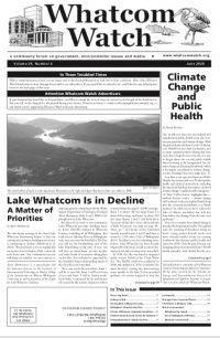
The above photo depicts Lake Whatcom on a late summer evening at sunset in Sudden Valley. photo: EJ Ledet
Lake Whatcom is the primary drinking water source for about 100,000 residents of Whatcom County. The lake is comprised of three sub-basins from which water samples are collected in October through December, in February and April through September each year.
The northernmost basin 1 (sample Site 1) is the smallest in area, 100 feet deep, and is surrounded by residential development.
Basin 2 (sample Site 2) is just south of basin 1, is second largest in area, 40-60 feet deep, and has the Sudden Valley residential subdivision along the western half of it.
Basin 3 (sample Site 3 (north) and Site 4 (south) is the largest in area, 328 feet deep, and contains 96 percent of the lake’s total volume. Residential development in this sub-watershed is sparse.
Since the mid-1980s, the Institute for Watershed Studies at Western Washington University has been collecting water samples, analyzing them, and reporting on the status of the lake as part of a long-term monitoring project for the city of Bellingham. Additional water quality data dating back to the 1960s also exists and have been used to provide an invaluable record of the lake’s decline over time.
The lake has been listed since 1998 as an impaired waterbody under Section 303(d) of the Clean Water Act. Once listed, the act requires that the waterbody must be cleaned up to meet state water quality standards by the persons or persons responsible.
The city of Bellingham, Whatcom County and the Lake Whatcom Water and Sewer District have formed a Lake Whatcom Management Committee to direct the restoration and preservation of the lake and its surrounding watershed.
The annual Lake Whatcom Monitoring Program provides long-term baseline water quality data on the lake, its tributaries, stormwater runoff treatment facilities around the lake, and hydrologic data to help the Lake Whatcom Management Committee in its decision-making and resource allocations.


