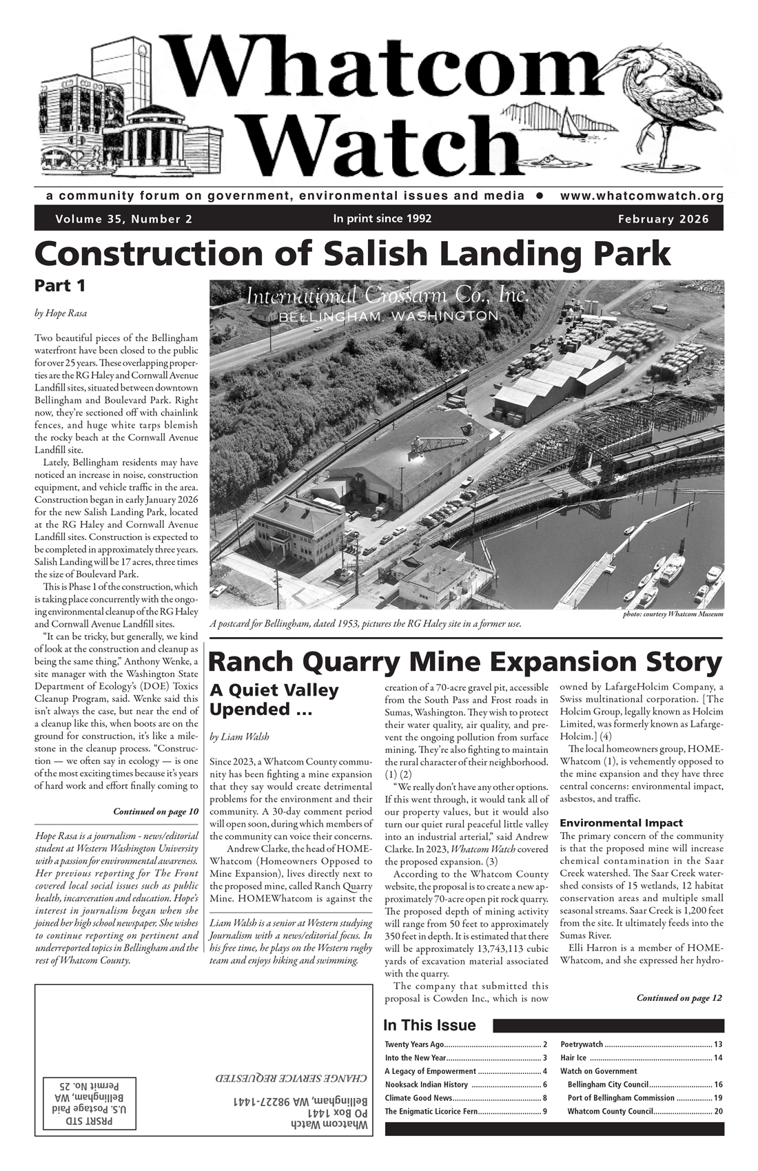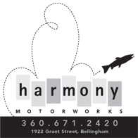
by Allan Richardson
Nooksack Indian history goes back thousands of years. According to native tradition, the people have been here from time immemorial — basically since the beginning of human existence on this land. There is nothing in Nooksack tradition of ever living anywhere else. Studies in linguistics and archaeology indicate a stable population of speakers of Salish languages, with no migration into the Georgia Straits/ Puget Sound region, for the past several thousand years. The Nooksack spoke a distinct Salishan language known as Nooksack, or Lhéchalosem, spoken only by them.
The Nooksack people occupied the watershed of the Nooksack River from the high mountain area surrounding Mt. Baker to the salt water at Bellingham Bay, and extending into Canada north of Lynden and in the Sumas area. Research has identified 25 traditional winter village sites, although no more than maybe 15 of these were occupied at any one time, even before the severe population decline of the historic period caused by the new diseases beginning 250 years ago.

Village Clusters Along Nooksack River
Most of these villages were in four clusters along the Nooksack River between modern Lynden and the mouth of the South Fork above Deming. Additional villages were located downriver from Lynden, in the Sumas area, and at Lake Whatcom. The Nooksack people used a broad area for hunting, fishing, gathering of foods, and travel to visit other groups. Map 1 shows the territory of the Nooksack and their neighbors in the early 19th century. (1)

Map 1. Territory of the Nooksack and adjacent groups, ca. 1820. This map, by Eric Leinberger, is reprinted with permission of the publisher from “Nooksack Place Names” by Allan Richardson and Brent Galloway© University of British Columbia Press 2011. All rights reserved by the publisher.
Who are the neighbors of the Nooksack shown on the tribal territories map? To the south are the Upper Skagit and Nuwhaha (now part of the Upper Skagit Tribe) who spoke the Lushootseed language; to the west are the Samish, Lummi, and Semiahmoo who spoke dialects of Northern Straits; to the north are the Chilliwack, Sumas, Matsqui, and other speakers of Halkomelem.
The map also shows the Skelakhan in a small area to the west of the Nooksack. “In 1820, the Skelakhan, or Sq’eláxen, were a small remnant population located on a prairie on the southeast bank of the Nooksack River near modern Ferndale, Washington. By the 1850s, the Sq’eláxen group no longer existed, although individuals of Sq’eláxen descent have been noted in the Nooksack and Lummi tribes. Some time before 1820, the Sq’eláxen occupied the mouth of the Nooksack River and controlled the surrounding saltwater areas, Lummi Bay and much of Bellingham Bay.” (2)
1855 Point Elliott Treaty
The Nooksack were one of many Indian groups which were party to the Point Elliott Treaty of 1855, in which title to the land of much of western Washington was exchanged for recognition of fishing, hunting and gathering rights, and a guarantee of certain government services. Some sources continue to claim that the Nooksack were not party to the Point Elliot Treaty, despite the fact that this issue was settled in federal court in 1974. Expert witness testimony showed that Governor Stevens and other members of the treaty commission considered Nooksack to be a party to the treaty. Historic documents state that 256 Nooksack people were present at the treaty grounds six days before the treaty was signed on January 22, 1855, and that there is nothing in the historic record to suggest that the Nooksack left the treaty grounds before the signing, or chose to be excluded. (3)
Under the terms of the Point Elliott Treaty, the Nooksack were not granted a reservation. They were expected to move to the Lummi Reservation, but few did. In 1873 and 1874, attempts were made to move the Nooksacks to the reservation, but it became clear that they would not move without military force and it was recommended that the Nooksack Indians be allowed to remain in the Nooksack Valley. (4) Following this, Nooksacks were able to gain legal title to small portions of their traditional lands, including many of the village sites, by filing homestead claims. The locations of the villages and homesteads are shown on Map 2.

map: Allan Richardson
Map 2. Nooksack Permanent Settlements and Homesteads, 1820-1895.
In order to obtain a land patent by homesteading, an Indian had to go through the same lengthy process that white settlers went through, plus procedures specific to Indian homesteaders. The basic steps were usually as follows:
- Declaration stating intent to file on a specific claim.
- Affidavit of eligibility (sworn statement stating eligibility to homestead, usually including abandonment of tribal relations, with sworn statements of two citizen witnesses).
- Homestead application and payment of fees.
- Continuous residence for five years and “improvements” on the land.
- Published notice of intent to prove up on the homestead.
- Final affidavit, testimony of homesteader and four witnesses, and payment of additional fees.
- Homestead certificate issued.
- Patent to land issued.
For the Nooksack homesteaders, non-Indian settlers provided essential assistance in following the procedures and acting as witnesses.
In 1874, only the lower, downriver Lynden and Everson areas had been surveyed, and were thus available for homesteading. Seven homestead applications were made by Nooksack Indians at this time, including the claims of James Seclamatan (Lynden Jim, Selhámetan), surrounding Sqwehálich, and of George Olooseus (Welósiws) surrounding Kwánech village. The Lynden Jim homestead was on Stickney Island, across the main 19th century river channel from Lynden, and the location of the Stickney Home mission school on land donated by Lynden Jim.
The George Olooseus homestead is now the center of the town of Everson. These first homesteads received 5-year restricted patents under provisions of an Act of Congress passed on March 3, 1875. Lands patented under this act were not, and could not become, trust lands. None of these lands are in Indian ownership today with the exception of the two tribal cemeteries on Northwood Road.
1884 Indian Homestead Act
Before more areas of the Nooksack River valley were opened for homesteading, the Indian Homestead Act of 1884 was passed.
This law included the following changes:
- All Indians, tribal and non-tribal, could take up homesteads on the same basis as citizens.
- No fees were to be charged for entry or proof.
- All patents were to be held in trust by the United States for 25 years, after which time a fee patent would be issued.
By executive orders, the trust period has been extended continuously to the present. (5)
As upriver areas were surveyed, 30 additional Indian homestead claims were filed, with 29 trust titles eventually granted to 3,847 acres. These trust homesteads included many village sites, including : Xelxál7altxw on the John Suchanon (Long Johnny) homestead, near Mission Road; Spálhxen on the Johnson homestead, north of Goshen Road; Yexsáy on the Sampson Santla homestead, near Lawrence Road; and Nuxw7íyem on the Charley Adass homestead at the mouth of the South Fork above Deming.
These lands have since been administered by the Bureau of Indian Affairs and some 2,400 acres remain in trust today, some held by the tribe, some by individuals, and much in complex multiple heirship. About half of the 2,000 enrolled members of the tribe currently live on or near Nooksack trust lands.
In just a few decades, Nooksack settlement was transformed from traditional villages of cedar plank longhouses to homesteads on a Euro-American model. By 1895, the Nooksack held secure title, as individuals, to a very small fraction of their traditional lands which had been almost entirely held in common. In spite of the change in land ownership, and despite living on small homestead farms, there were many continuities with the traditional past.
The homesteads were all within a short distance of the traditional villages, which were also small and scattered. After homesteading, and well into the 20th century, the Nooksack people continued to depend heavily for food on fishing, hunting, and gathering at traditional places.
Since the Nooksack were not granted a separate reservation, they were no longer recognized as a tribe by the Bureau of Indian Affairs, yet they continued to function as a tribe. In 1926, they met under the leadership of George Swanaset to join in the Duwamish, et al. v. The United States case before the Court of Claims; in 1935, the Nooksack tribe voted to accept the Indian Reorganization Act, but was not permitted to organize under the act since it was not a recognized tribe. In the 1950s, the tribe under the leadership of Joe Louie pursued a land claim case with the Indian Claims Commission (ICC).
1955: Nooksack Officially Deemed Tribe
The ICC decided in 1955 that the Nooksack were indeed a tribe of Indians whose lands had been taken without compensation, but that they only “exclusively occupied and used” a small portion of their traditional territory (Indian Claims Commission, Docket No. 46). It was further decided that the value of the lands at the time of the treaty was $0.65 per acre and only this amount would be paid. A payment of $43,383 for 80,000 acres of the 400,000 acres claimed was provided by Congress in 1965.
The 400,000-acre claim approximates the area of Nooksack territory shown on Map 1, and includes a large majority of the places named in the Nooksack language that are south of the U.S.-Canada boundary. The land claim money was distributed in equal portions on a per capita basis to each recognized descendant of the Nooksack tribe of 1855. (6)
In the 1960s, the tribe had a Community Action Program and launched an effort to gain federal recognition. In 1970, the tribe gained title to four buildings on an acre of land, which became the Nooksack Reservation and is the location of the present-day tribal enterprises in Deming. In 1973, full federal recognition was granted. With recognition, the Nooksack Tribe has built a wide range of tribal programs and expanded its land holdings.
In 1974, the Nooksack Tribe joined the United States v. Washington case as a treaty tribe with fishing rights for enrolled members. As a result, a major focus of Nooksack tribal programs today is land and resources with a special emphasis on fishing. Fishing in the Nooksack River and saltwater areas is an important source of income and food for many families, as well as being a source of cultural pride and identity. The tribal fisheries program regulates fishing and works to enhance fish runs and protect the environment which the fish depend on. The tribe works closely with local, state, and federal agencies to review proposed developments, timber harvests and other environmental disturbances, and evaluate their impact on water quality, fisheries, and cultural sites.
Summary
Nooksack Indian history is generally similar to the history of neighboring Coast Salish peoples in Washington state. Contact with Europeans and their diseases began in the late 1700s. Trading for furs and other resources began early in the 19th century, with settlement beginning soon after the international boundary treaty of 1846.
Almost all tribes in western Washington signed treaties in 1854 or 1855 in which their lands were ceded and reservations established. Soon the people and their remaining lands were under the control of the Bureau of Indian Affairs. Tribal sovereignty and self-government have gradually replaced outside control, beginning in the 1960s.
Nooksack tribal history is different in that they were an off reservation community, not a recognized tribe, for over a century. This is similar to the history of the Upper Skagit, Sauk-Suiattle, Stillaguamish, and Samish Tribes in our area, but in contrast to the reservation-based Lummi, Swinomish, and Tulalip.
____________________________________
Allan Richardson received an M.A. in Anthropology from the University of Washington, Seattle, and taught Anthropology at Whatcom Community College for 38 years. He has published articles on Northwest Coast native culture and has served as consultant to the Nooksack Indian Tribe for a number of grants and legal cases. Mr. Richardson is coauthor with Dr. Brent Galloway of the book “Nooksack Place Names: Geography, Culture, and Language” (UBC Press, 2011). He is also active in the Washington Native Plant Society, lives on a small farm on the outskirts of Bellingham.
References:
- Richardson, A. & Galloway, B. (2011). “Nooksack Place Names: Geography, Culture, and Language,” Vancouver, BC: University of British Columbia Press.
- Richardson, A. & Galloway, B. (2011). “Nooksack Place Names: Geography, Culture, and Language,” Vancouver, BC: University of British Columbia Press, page 19.
- Lane, B. (1974). “Identity and Treaty Status of the Nooksack Indians.” Written testimony dated November 28, 1974, United States v. Washington, 384 F.Supp. 312 (W.D. Wash. 1974).
- Richardson, A. (1979). “Longhouses to Homesteads: Nooksack Indian Settlement, 1820-1895.” American Indian Journal 5, no. 8 (August): 8-12.
- Richardson, A. (1979). “Longhouses to Homesteads: Nooksack Indian Settlement, 1820-1895.” American Indian Journal 5, no. 8 (August): 8-12.
- Richardson, A. & Galloway, B. (2011). “Nooksack Place Names: Geography, Culture, and Language,” Vancouver, BC: University of British Columbia Press, page 22.