by Ron Kleinknecht
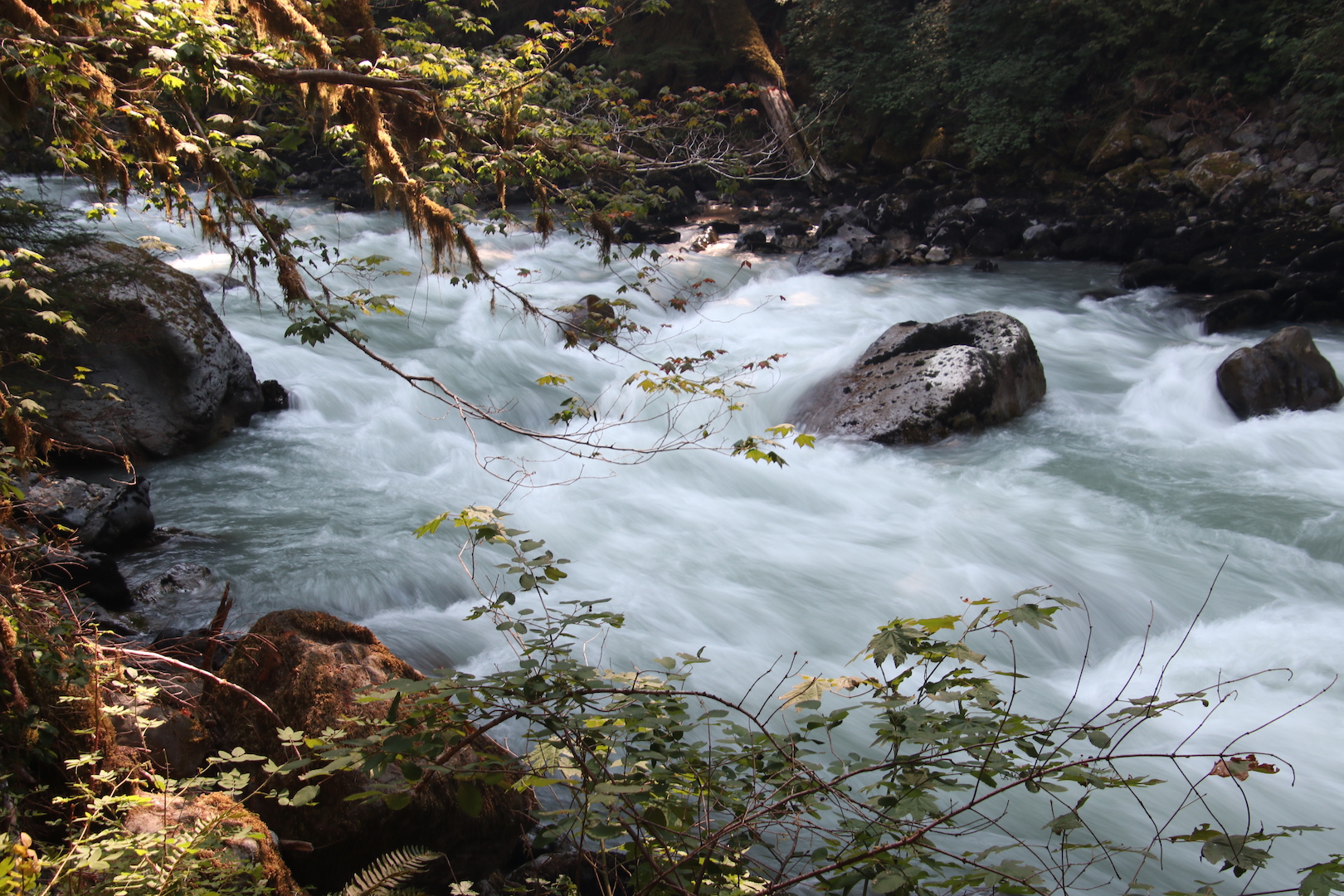
North Fork of the Nooksack rapids at Horseshoe Bend photo: Ron Kleinknecht
Part 1
Lay of the River
The Nooksack River is neither a large nor a long river by most standards as it runs only 75 miles from its origin in the glaciers of the North Cascade Mountains to its delta and mouth where it empties into Bellingham Bay to become part of the Salish Sea.
However, its relatively small size does not diminish its importance to the Pacific Northwest and its marine environment. The Nooksack is one of the few streams in the Pacific Northwest that supports all five native Pacific salmon species as well other salmonids, such as steelhead and the rare bull trout.
This river’s name recognizes the Salishan speaking tribes of Southwest British Columbia and Northwest Washington/Puget Sound. The name “Nooksack” comes from a Salish place name that translates to “always bracken fern roots,” a food staple for this and many Native American populations. Applied to the tribe, their area included the mountains, valleys, the watersheds and shores of this river and its surrounding territory. (1) However, they seem not to have had a specific name for the river as a whole, other than “river,” although they did have place names for various fishing, digging and hunting sites along the river and throughout its tributaries and watershed.
The river comprises three forks and numerous smaller tributary creeks that converge to form the Nooksack River before it flows into Bellingham Bay. Each of the forks originates within the Mount Baker-Snoqualmie National Forest and the Mount Baker Wilderness Area. I’ll describe the source area for each fork and its confluence with the main stream. These forks drain the forest basin of 786 square miles of this portion of the Cascade Range including the glaciers of Mt. Shuksan, Mt. Baker and the Twin Sisters Range, and reaches in part across the border into Canada. (2)
North Fork
The North Fork of the Nooksack originates on the north side of Mt. Shuksan (Salish for ‘Steep and Rugged”) (1) where its glaciers drain into the Nooksack Cirque, and, along with numerous creeks, becomes the headwaters of the river.
This fork is considered part of the main river as it connects with various tributary creeks along the way and then with the Middle Fork and the South Fork to form the final version of the river.
The North Fork is probably the most scenic fork as it originates from the glaciers of Mt. Shuksan and Mt. Baker mostly from the north side. The river then runs through old growth forest, steep canyons and waterfalls and eventually wends through lowland farm country to the Lummi Indian Reservation, which hosts its delta and its entry into Bellingham Bay.
Only 12 miles from its origin, the North Fork comes to the 88-foot-high Nooksack Falls, which is a scenic and popular photo site. Sadly, this beautiful falls has a deadly history as at least 11 people have fallen off the cliff into the plunge pool, lured by trying to get a better view. It is now quite heavily fenced.
Moving west, the North Fork careens through some sheer walled canyons filled with boulders and downed trees that build into white water rapids. A wonderful trail follows along the river at Horseshoe Bend and then rises along the canyon wall above the river into some lush forest environs.
The North Fork and its surrounding watershed area are very popular for recreation of many kinds, including camping — there are three National Forest campgrounds along this segment of the river, as well as several private vacation communities. Other recreational activities available along this fork include: mountain climbing, hiking, fishing, whitewater kayaking (Class III and IV), river rafting, picnicking, and, in the winter, skiing, snowshoeing and eagle watching, not to mention photographing all of the preceding activities.
As I noted above, this river is a prime spawning stream for all species of Pacific salmon. After the eggs hatch, the fry hang around in quiet pools, growing and maturing for a year or so before beginning their journey downstream to estuaries. There they become smolts while adapting to the saltwater environment before embarking on their journey to the Pacific Ocean.
Shale, sandstone and various igneous and metamorphic rocks litter the riverbed and bars that are exposed during low-water times. Parts of this riverbed are directly below Slide Mountain, which is part of the Chuckanut Formation, a 54-million-year-old sedimentary rock formation from the Eocene Epoch. These sedimentary rocks, sloughed off from eons of landslides, yield numerous prehistoric leaf fossils. (4)
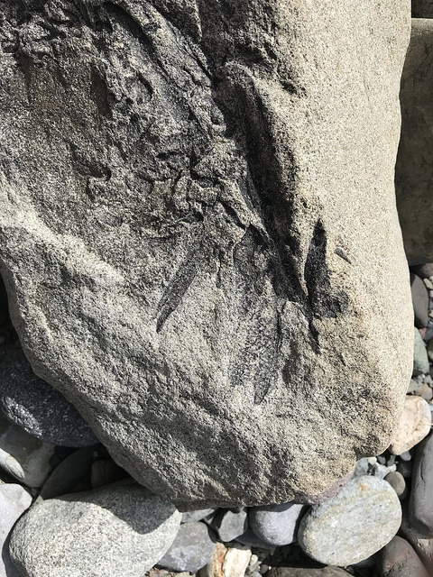
Fossils photo: Ron Kleinknecht
For example, on one of our family forays onto the river bars along the North Fork at Wildcat Reach, I began breaking some of the shale stones to check their insides. Sure enough, before long everyone in our little group was finding and exposing leaf fossils that had been hidden inside for over 50 million years.
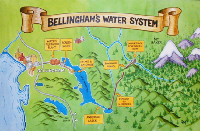
The Middle Fork Nooksack River originates from the base of the Deming Glacier on the slopes of Mount Baker. (3) A portion of the Middle Fork is diverted into Lake Whatcom, which is Bellingham’s drinking water source. Courtesy city of Bellingham

Workers in the 1960s excavated and formed the water conveyance tunnel through Bowman Mountain, which diverts water from the Middle Fork of the Nooksack to Lake Whatcom. Photo: Jack Carver, courtesy Whatcom Museum
Middle Fork
The Middle Fork originates from glaciers such as Deming and Thunder on the western slopes of Mt. Baker (Komo Kulshan and variants thereof in the Salish language) (1). The connecting creeks gathering the runoff from Mt. Baker initially run west through some difficult-to-access old growth Douglas fir and Western red cedar. As the creeks converge to form the Middle Fork, they turn north and connect with the North Fork in the Welcome area.
Just a bit upstream from the confluence of these two forks is a favorite feeding spot for bald eagles during the winter when recently spawned salmon carcasses are abundant. The Welcome Bridge at Welcome on Mosquito Lake Road provides a popular eagle viewing spot in December and January. (5)
The Middle Fork falls rapidly from the big mountain’s glaciers and moves fast before meeting the North Fork. It has some class V whitewater rapids for competitive kayakers. This fast moving, tumbling part of the river was referred to by native Nooksacks as “always murky water” as it was always stirred up from glacial melt and fast running. (1)
South Fork
The South Fork originates between Mt. Baker and two peaks immediately to its west called the Twin Sisters Range. The South Fork’s largest tributary stream, Skookum Creek, originates on the western slopes of the Twin Sisters. Once a pristine and productive creek, its water quality has deteriorated in recent years since its watershed and adjacent areas have been heavily logged. (6,7)
Being the largest single contributing stream to the South Fork, Skookum’s quality impacts that of the larger stream, which is currently listed under the Clean Water Act (CWA) as an impaired waterway for both temperature and fine sediment load under the federal Clean Water Act. (8) Fortunately, the Whatcom Land Trust is in the process of purchasing 1,400 acres of the riparian habitat and wetlands surrounding the creek and its watershed as it courses down to meet the South Fork. The Land Trust’s purchase of the Skookum property will preserve this wonderful creek for posterity. A virtual tour of Skookum Creek is available here: https://www.youtube.com/watch?v=wiQfrAJSH3U&feature=youtube.be.
After winding around the south end of the Sisters, this fork meanders northerly through Acme and the South Fork Valley farmland running past several dairies including a Yak farm on Mosquito Lake Road.
This lower part of the river seems downright lethargic compared with rough and tumble of its upstream counterparts. Instead of whitewater rafting or kayaking, the South Fork is known for its recreational use of inner tubing. This fork does not come off glaciers as do the other two forks, and is therefore warmer, which allows for actually being in the water, at least in the summer months. However, this warmer water is not great for salmon which like cold water, but it remains a popular sport salmon fishing site.
The South Fork’s slowness and lack of turbidity is also why the Nooksack Indians historically referred to this fork as “always clear water.” (1)
From Delta to the Bay
From the South Fork’s confluence with the main stream just east of Deming, it is just about 17 miles from Bellingham Bay as the crow flies, but the river takes a circuitous route that wends itself another 35 miles before reaching the bay. That course heads north at Nugent’s Corner and flows nearly to the Canadian border before turning west toward the Salish Sea and finally south where it empties into Bellingham Bay. These last 35 miles cut through highly fertile agricultural lands that were the first parts of the county to be settled in the mid-1800s. The river now flows along diked shores that restrain the river from flooding the prime agricultural fields that include raspberry, strawberry and blueberry farms, as well as numerous dairies.
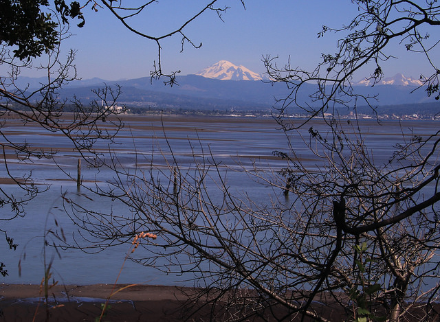
Nooksack River Delta photo: Ron Kleinknecht
The Nooksack’s final few miles after passing Ferndale branches out into several channels that run through the Lummi Reservation before emptying into Bellingham Bay. The Nooksack tribe referred to these branching channels as “the place of many arms.” (1)
This last segment foreshadows the topic to be addressed in Parts 2, 3 and 4 of this series, in which I will present the past, present and potential harms that endanger this river and its precious denizens, the salmonids (salmon and their trout relatives). Although much harm has come to the Nooksack River and basin, much is being done to reclaim this once pristine region that is home to now threatened and endangered Pacific salmon.
The salmon’s fate is not theirs alone. Their fate, in turn, is critical to sustaining the Lummi and Nooksack tribes, as well as our other aquatic icon, the resident orca whales of the Salish Sea, which themselves are in mortal danger today. (9)
References
1. Richardson, A. and Galloway, B. (2012). “Nooksack Place Names: Geography, Culture and Language.” UBC Press, Vancouver, Canada.
2. https://en.wikipedia.org/wiki/Nooksack_River
3. http://www.arcgis.com/apps/MapJournal/index.html?appid=6119202fe2f8434db4c43c4d8920d209
4. Tucker, D. (2015) “Geology Underfoot in Western Washington.” Mountain Press, Missoula, MT.
5. https://www.bellingham.org/insider-blogs/3-tips-for-eagle-watching-with-the-family/
7. Whatcom Land Trust Staff. Whatcom Watch, (Dec. 2018), vol. 27 (12). “Skookum Creek Conservation Corridor.”
Editor’s Note: This article has been updated by the author for Whatcom Watch after first being published online at the Daily Kos.
Next Month: Part 2
The History and Current State of the River.
_______________________________________
Ron Kleinknecht is professor emeritus of psychology and dean emeritus of Western Washington University’s College of Humanities and Social Sciences. He’s a lifelong nature and conservation enthusiast who writes about the Pacific Northwest and is a volunteer land steward for the Whatcom Land Trust.